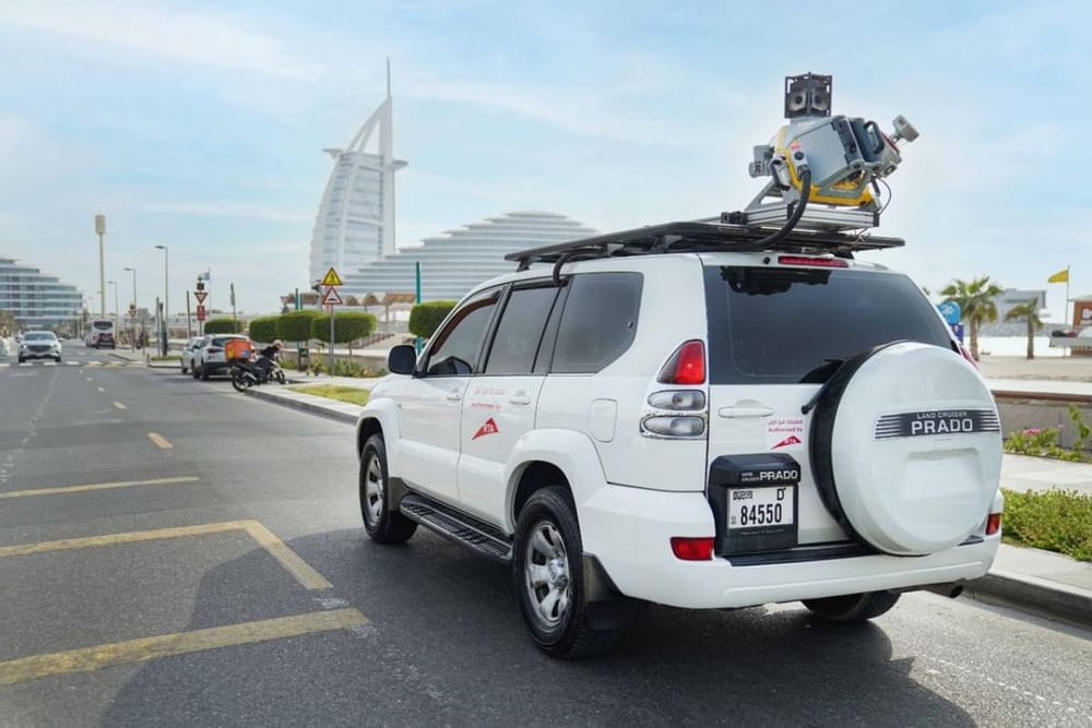
Dubai’s Roads and Transport Authority (RTA) has rolled out LiDAR (Light Detection and Ranging) technology to transform how the Emirate assesses and maintains its road infrastructure.
This move marks a significant step in advancing smart asset management and supporting Dubai’s vision of becoming a global leader in smart, sustainable urban development.
The integration of LiDAR technology allows for highly accurate and rapid assessments of road assets, achieving up to 95% accuracy—well above that of traditional visual inspections. It also enables the daily evaluation of up to 80 km of roads, a dramatic 96% improvement over conventional methods, which typically assess just 3 km. These inspections can be conducted seamlessly while driving at speeds of 30 to 100 km/h, without disrupting traffic flow.
“LiDAR technology delivers a performance leap of up to 300%, reinforcing RTA’s digital transformation journey,”
said Hussain Al Banna, CEO of the Traffic and Roads Agency at RTA.
“It enhances data quality, speeds up maintenance planning, and ensures the safe, efficient inspection of elevated assets like lighting poles and road signs.”
With a sensing range of 80 metres, LiDAR offers comprehensive coverage of road infrastructure, supporting continuous data updates and improved decision-making. This technology plays a vital role in enabling predictive and proactive maintenance strategies, thereby enhancing road safety, reducing risks associated with manual inspections, and extending the lifespan of critical assets.
Al Banna emphasised that the technology also supports the long-term sustainability of the Asset Condition Index (ACI), helping prioritise interventions based on strategic needs. Ultimately, the adoption of LiDAR is a cornerstone in RTA’s commitment to maintaining resilient, high-quality road networks and delivering world-class mobility services in line with Dubai’s smart city ambitions.
News Source: Emirates News Agency