The International Research Institute of Disaster Science (IRIDeS) at Tohoku University, the Earthquake Research Institute at the University of Tokyo, Fujitsu, and the City of Kawasaki today announced plans to conduct a field trial of AI that is constructed on the world's fastest supercomputer, Japan's Fugaku, and provide high-resolution, real time tsunami flooding forecast for supporting safe and efficient tsunami evacuations during disaster prevention drills in Kawasaki, Japan on Saturday, March 12, 2022.
During this field trial, participants from the surrounding community will be notified about the arrival time and the flooding height of a predicted tsunami through a special smartphone application developed by Fujitsu. The exercise aims to identify the most effective ways to use the technology to support local communities in sharing information amongst residents and avoid cases of people being left behind during evacuations.
This project represents the latest milestone in an ongoing initiative between the parties. As part of a framework agreement signed between Kawasaki City and Fujitsu in 2014 to promote the creation of sustainable communities, the four parties have been engaging in R&D activities as part of the "Joint Project Aiming for Tsunami Disaster Risk Reduction Using ICT in the Kawasaki Coastal Area" since 2017.
Verifying the effectiveness of information sharing amongst field trial participants via the app, the parties aim to further promote the practical use of disaster risk mitigation methodologies that leverage the capabilities of AI, high performance computing (HPC), and communications technologies for tsunami flooding forecasts, ultimately contributing to the realization of a safer society.
Background
Recent years have witnessed the development of several different technologies for real time tsunami flooding forecasts that make use of the capabilities of high-speed supercomputers and AI.
Barriers to the practical deployment of such technologies remain, however, including how to share relevant information in an inclusive yet effective manner to the public, taking into account individual differences of users and varying levels of digital literacy.
The four parties aim to address some of these challenges by conducting a field trial to test the technology with actual residents of the community in circumstances that replicate the uncertainty of an actual disaster, including the possibility that the AI forecast information itself isn't 100% certain.
Outline of the field trial
Date: March 12, 2022 (Saturday) 8: 15 to 11: 15 JST (held at the same time as the comprehensive disaster prevention drills in Kawasaki Ward)
Place: Kawasaki Municipal Kawanakajima Junior High School and surrounding area (Kawasaki Ward, Kawasaki City)
Participants: local residents and project members
Overview: Field trial to verify the effectiveness of evacuation using AI tsunami flooding forecast data. This data will be delivered to a dedicated app developed by Fujitsu, which residents and organizers will refer to in real time during a simulated evacuation.
The field trial will be conducted under the supervision and guidance of Prof. Fumihiko Imamura, Director of the International Research Institute of Disaster Science at Tohoku University and Prof. Takashi Furumura at the Earthquake Research Institute at the University of Tokyo.
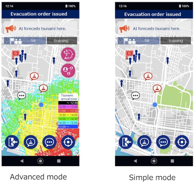
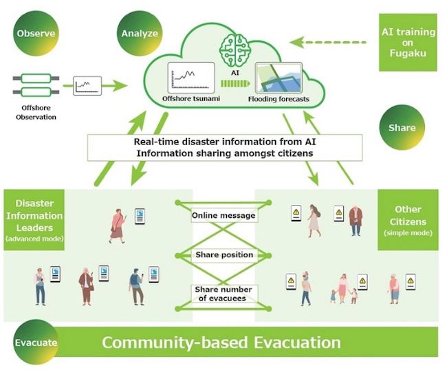
Several participants briefed in advance of the field trial (including the possibility that AI forecast information isn't 100% certain) will act as disaster information leaders and receive detailed information including the predicted arrival time and flooding height of the tsunami. Other participants will receive a text message on the app indicating that AI has forecast flooding for their location.
When evacuating, disaster information leaders can check the current location of participants in the same community and alert those who are behind in evacuating by using the app's messaging function.
The field trial will be followed by an online disaster prevention course, in which evacuation actions of the participants will be reviewed.
About the app
The app has two display modes. The first one is a detailed mode, in which AI-generated tsunami flooding forecast data is displayed on a map in different colors corresponding to the arrival time and the flooding height of the incoming tsunami. The second mode is a simple display that only shows a text message warning users in a certain area about the predicted tsunami flooding.
The app also includes a messaging function that allows users to check the location of other community members on a map and help one another to communicate and gather safely during the evacuation.
Users can further post and share information on points along evacuation routes that are assumed to be damaged and difficult to pass (a function which has been validated in prior field trials) and also share real-time information about the number of people who have successfully evacuated and gathered at evacuation centers.
Future Plans
Based on the feedback from the participants of the field trial, the four parties will further investigate methods to transmit and use AI disaster forecasting to realize safer and more efficient community-based evacuation and promote the use and practical application of AI to support disaster mitigation measures and contribute to the realization of safer local communities.
News Source: JCN Newswire